ENZO HOME  -  HOME

Glynneath residents. Are the Neath-Port Talbot Council Planning your Death?


  72-title.jpg (354465 bytes) In this video we ask a series of questions ending in

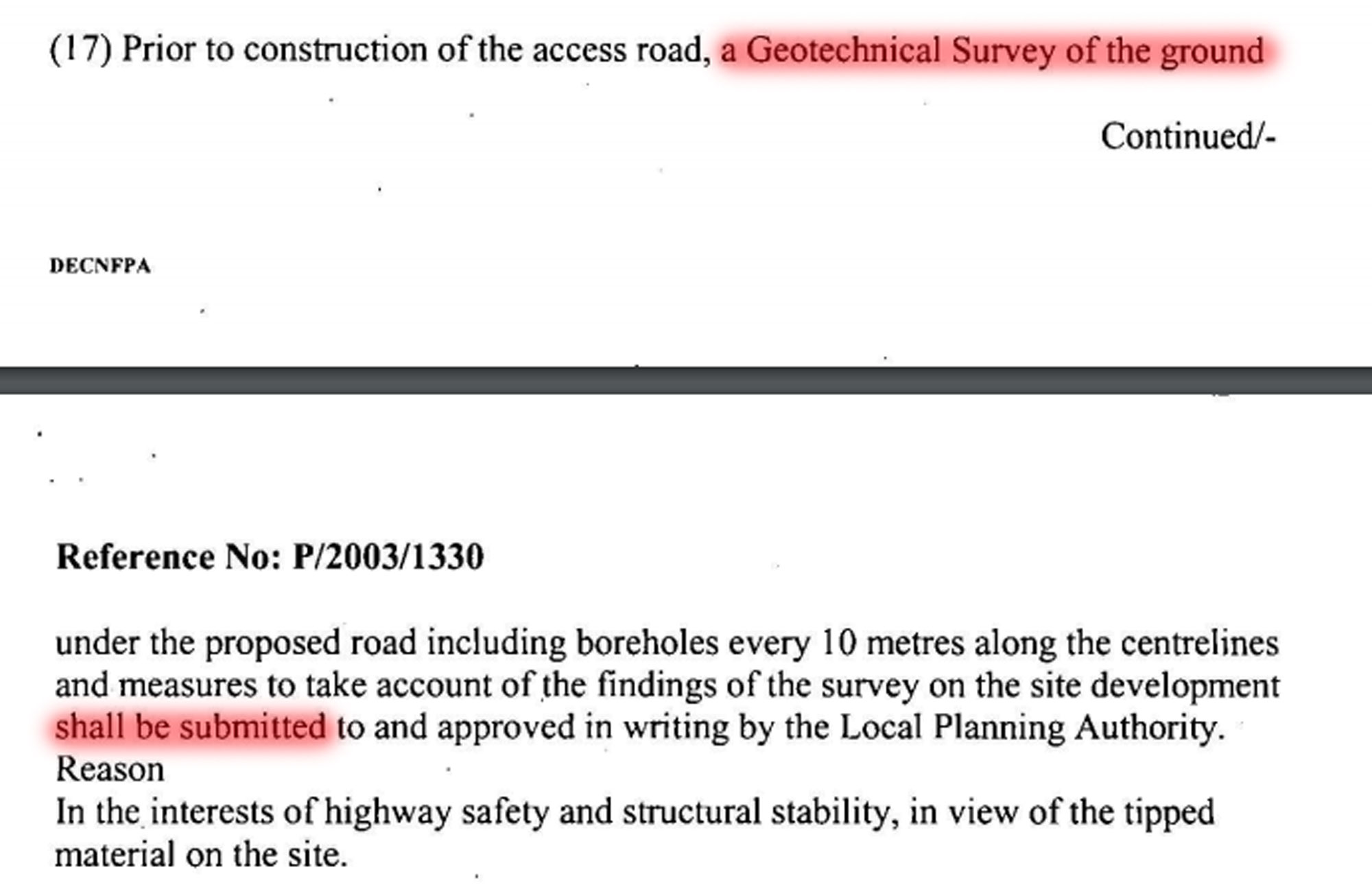
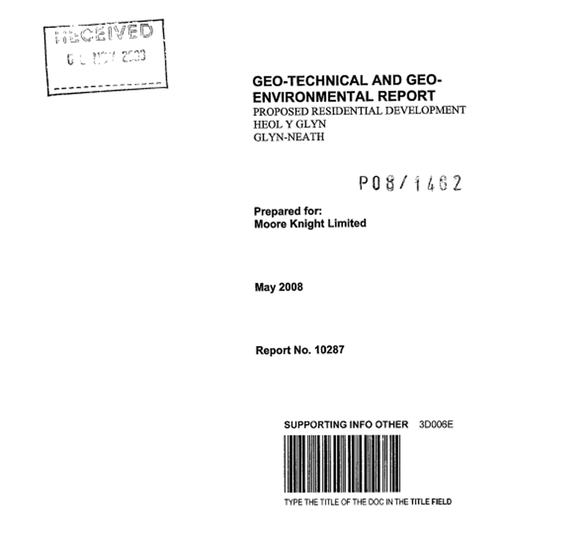
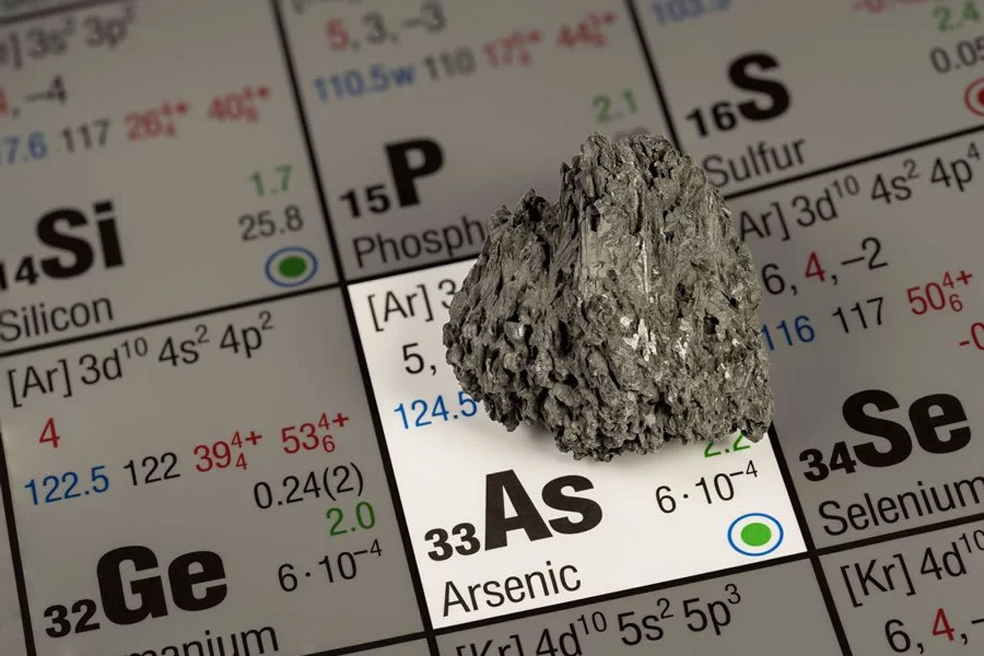
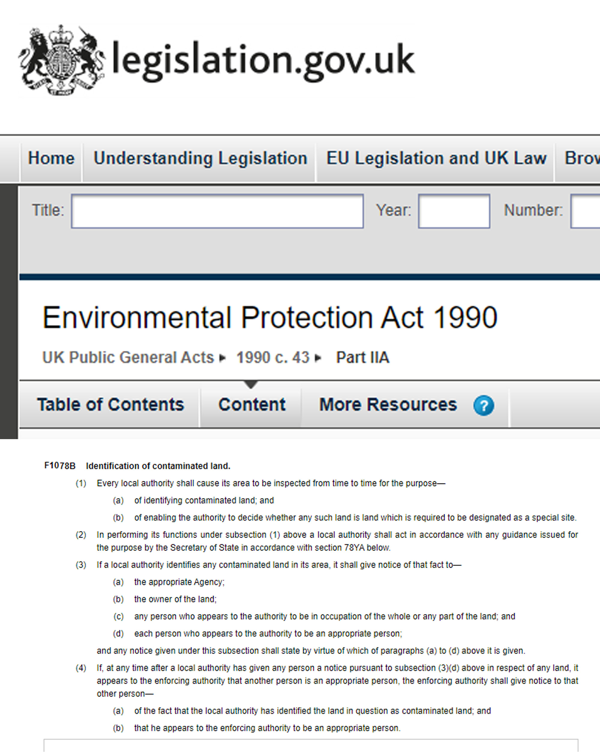
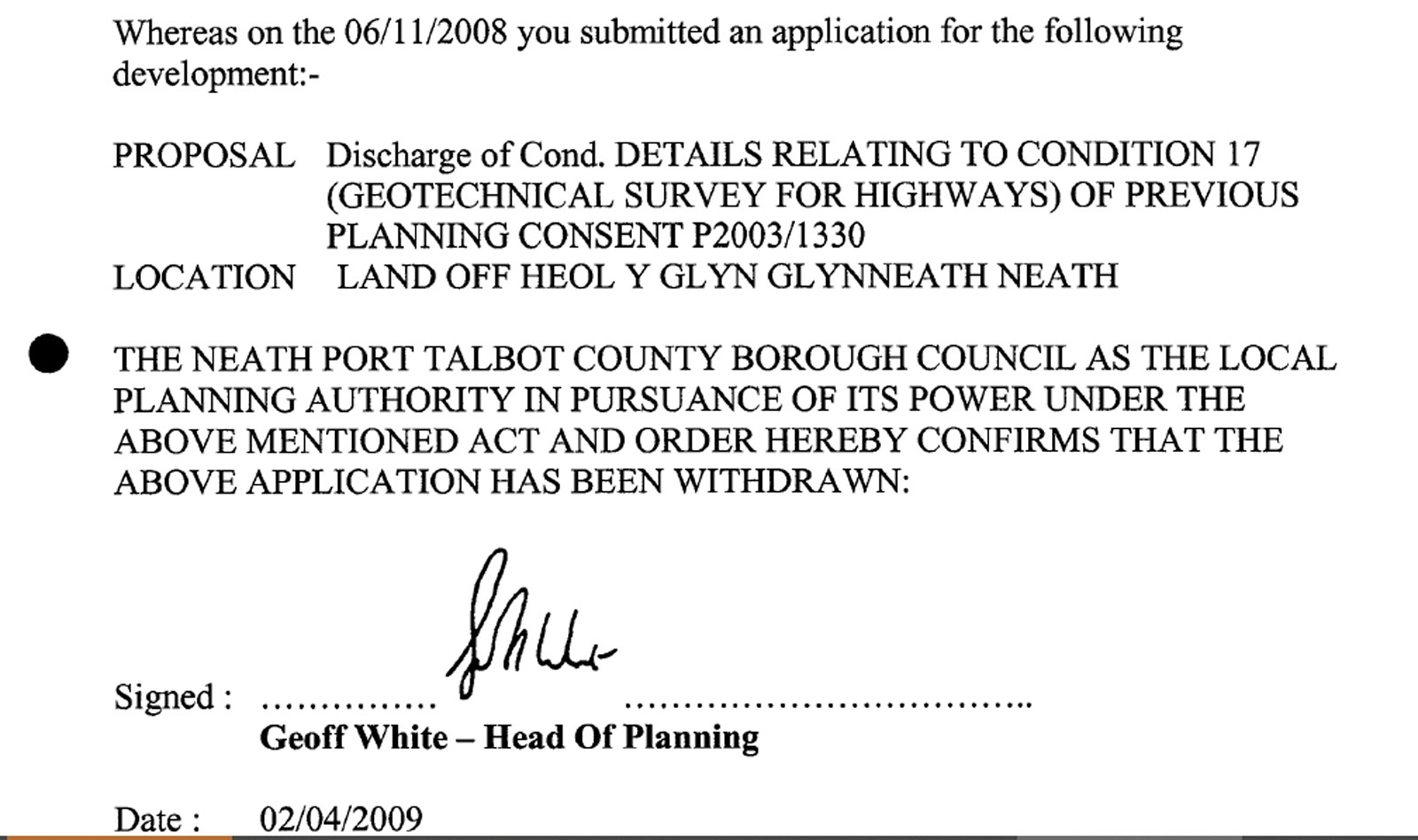
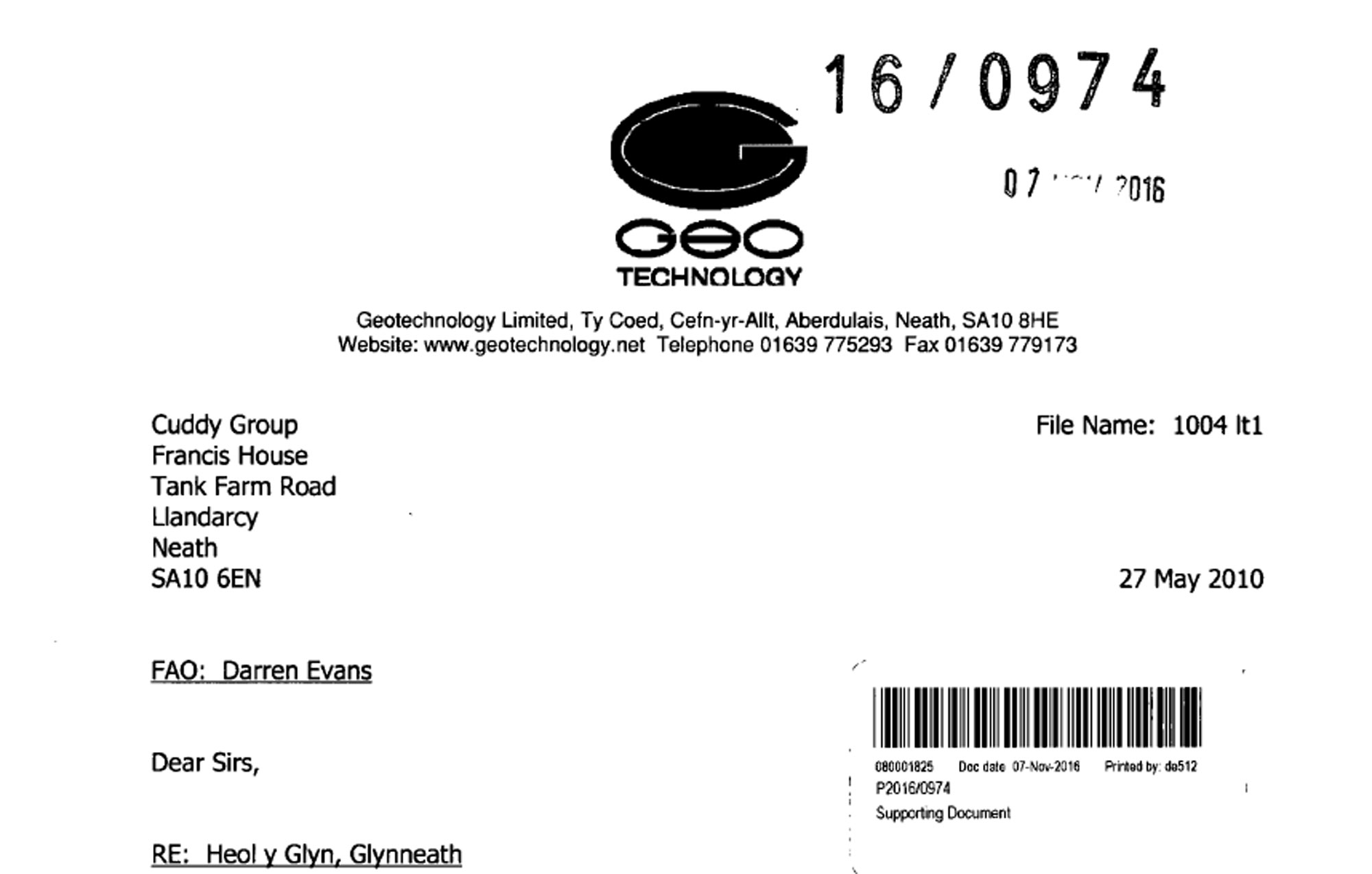
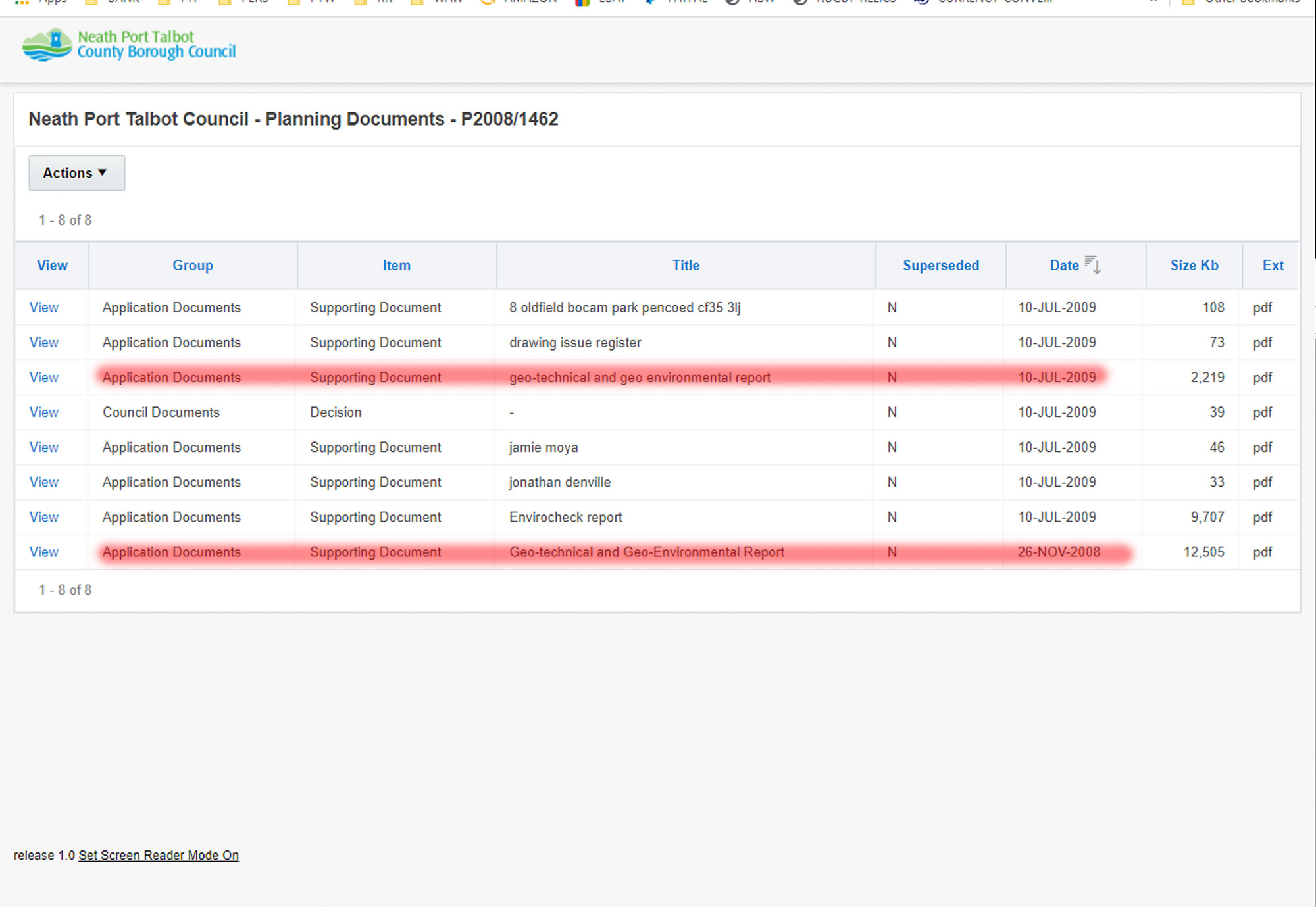
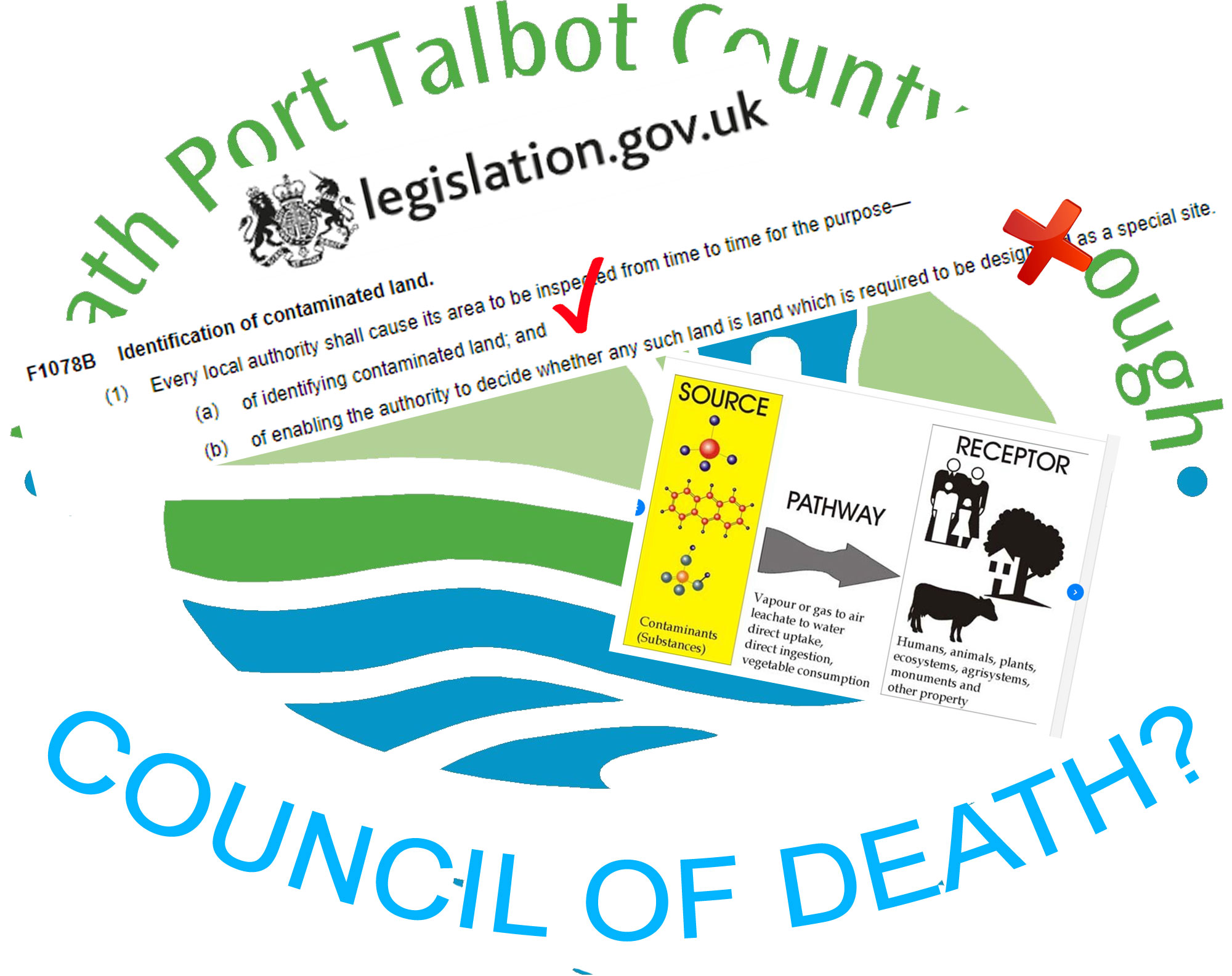
Are the Neath-Port Talbot Council planning the death of Glynneath residents?

We show how it is possible that the Neath Port Talbot Council have broken the Environmental Protection Act 1990 and placed the lives of the people of Glynneath at risk from cancer causing chemicals. The result of these actions may have resulted in the death of Glynneath residents. 


INTRO - BACKGROUND INFO

me arriving in front of the board and looking up    
view of the site and Enzo info board in the distance - cars passing   To the local council this land known is known as "the land south of Heol y Glyn in Glynneath" To local residents it is known as the 'ash tip' or just the 'tip'.
view of the site from the board   The reason for this is because for the majority of the last 80 years the land has been both domestic and industrial landfill, a council tip from around 1940 to 1970 and industrial landfill since then. It was once owned by the asbestos removal experts, the Cuddy Group who at one time were the 12th largest demolition contractor in the world, a lot of their waste has been tipped here. 
cut to the board and  

enzo intro in front of sign


The Neath-Port Talbot Council first gave planning permission for a housing development at the site in 1989. 

Returning home and the action of visiting the NPTC planning website   In 2005 planning permission was granted again to the Cuddy Group and the NPTC placed a list conditions on this permission which the developer had to meet in order for them to complete the development..
condition 17 image 91-cond-17.jpg (168058 bytes)

One of these conditions was that a "Geotechnical Survey" of the ground be submitted . 

front cover 90-survey.jpg (127721 bytes)

92-approval.jpg (265698 bytes)

As part of this condition, a Geo-technical and Geo-environmental report was submitted on the 26 November 2008. 

Was Contaminated Land Identified ?

contamination evidence 89-contam.jpg (117312 bytes)

The report tested the land for contamination and it found that of the 6 soil samples sent for chemical testing, 4 tested above the recognised safe levels for the presence of a recognised contaminants.

arsenic slide


88-arsenic.jpg (279356 bytes) these included two grade 1 classified carcinogens 

Arsenic

BaP slide

87-bap.jpg (310158 bytes) and a polycyclic aromatic hydrocarbon called Benzo[a]pyrene.
  00y.jpg (100841 bytes) Under contaminated land regulations and guidance to local authorities, the presence of contaminants does not give land contaminated status. What identifies land as contaminated in the eyes of the UK and Welsh Governments is the identification of a source to receptor pathway. 
source  80-2000.jpg (204999 bytes) In layman's terms, if the contamination can move from its source (the ground) to a receptor (human beings) via a pathway (ingestion, inhalation) then the ground is considered to be a category of contamination. There are 4 categories of contamination with category 1 being the most serious and category 4 the least. Categories 1 and 2 require further investigation and/or remediation by law. This law is the 

The Environment Protection Act 1990

  96-human-health-7-1-risk-as.gif (510303 bytes) If we refer back to the Geo-technical report we will see that the survey provided evidence of a pathway from source to construction workers and residents of the development as category 2 contamination and the local residents as category 3 if contingency measures such as protective fencing and dust supression were put in place.  
remediation strategy and valid report 86.jpg (314618 bytes) Clear evidence that the Geo-Technical survey considered  the land to be contaminated is provided by the report which includes a Remediation Strategy (clean up operation) and Validation Report. 

Was Contaminated Land Identified ?

YES

What should have happened then?

CLS 2005 85.jpg (164681 bytes)

The Neath-Port Talbot Council regulations for contaminated land in 2008 were contained in the 2005 NPTC Contaminated Land Strategy. This document states 

fading in to 82

84.jpg (431147 bytes)

83.jpg (259614 bytes)

82.jpg (61260 bytes)

"Part IIA of the Environment Protection Act 1990, was introduced in Wales on July 1st 2001, until this time there had been no strategic approach to the identification of contaminated land. Land contamination had always been addressed during redevelopment or when the risk has manifested itself. Since 2001, all local authorities have a duty to inspect their areas, locate and ensure the remediation of all statutory designated contaminated land. One of the key objectives of the council's strategy (Key Objective 4:) is to ensure that during the redevelopment of new sites, land contamination issues are dealt with effectively and at an early stage of the planning process."
EPA 81-epa-1990.jpg (214055 bytes)

The document says that the contamination should have been dealt in the early stages of the planning process and if we refer to the..................

Environmental Protection Act 1990 - Part IIA

........Identification of contaminated land.

The opening points of which are................

EPA image tick and cross 80-epa-text.jpg (539597 bytes)

(a) of identifying contaminated land; and

(b) of enabling the authority to decide whether any such land is land which is required to be designated as a special site

This video will show that the Neath-Port Talbot Council identified contaminated land but rather than deciding whether the land was required to be designated as a special site, instead they worked together with the Cuddy Group to hide the contamination. 

Thereby placing the residents of Glynneath at risk from cancer causing chemicals.

Evidence of contamination

join images 80-2000.jpg (204999 bytes)

96-human-health-7-1-risk-as.gif (510303 bytes)

If we refer back to the information contained in the report we will see that the council was provided with information that the land was contaminated.

a source to receptor pathway was identified for three separate groups of people, construction workers, neighbouring residents and future residents of the site.. 

  77-epa-1990-tick.jpg (541621 bytes) and so part (a) of the council's obligations were completed. Contaminated land had been identified.
  76-epa-1990.jpg (78222 bytes) At this point the Neath-Port Talbot Council should have referred to point (b) of the Enviroment Protection Act 1990

(b) of enabling the authority to decide whether any such land is land which is required to be designated as a special site

  79-special-sites.jpg (1011228 bytes) By special site the act identifies a whole list of possibilities and complex variations so what we've done is identify similar instances. 

At this point in time (2009) the overall responsibility for governing contaminated land in England and Wales was with the UK Governments' Environment Agency so for similar cases we can look to other local authorities in England and Wales...........

  94.jpg (478245 bytes) Similar instances of land contaminated by Benzo[a]pyrene can be found in both Reading and Slough.
  93-slough-contam.jpg (433302 bytes)  Both these English authorities identified that Benzo[a]pyrene was present at unsafe levels and both councils we can see acted appropriately and designated the land contaminated under the 1990 Environment Protection Act.
  85.jpg (164681 bytes) This is what should have happened in Neath-Port Talbot with the Heol y Glyn development. If we refer again to the NPTC CLS 2005 we will see what the responsibilities of the planning department are at this point in time are:


  78-cls-2005-p15.jpg (215021 bytes) "When considering development proposals, the planning authorities role is to ensure that all material planning considerations, which can include the actual or possible presence of contamination are satisfactorily addressed. When considering an application, where contaminated land is involved the planning authority will identify specific measures to be undertaken prior to redevelopment, these requirements will be imposed by a set of conditions attached to the planning permission. The main objective of the conditions is to ensure suitable investigation work is carried out and that the land is remediated to a standard that is suitable for the proposed end use."

What did happen?

  89.jpg (183414 bytes)


The application containing the Geo-Technical survey with the contamination information was withdrawn on 2/4/2009.

No reason was given for its withdrawal and the Geo-technical and Geo-environmental report or contamination within it were never referred to again in the planning process until we discovered it in the planning department archives in March 2020.


  92-approval.jpg (265698 bytes) On the 23 April 2010 the Neath Port Talbot Council planning department approved a new set of plans for the development. The conditions did not mention contamination, chemical testing or any remediation of the site. 
  85.jpg (164681 bytes) If we refer again to the Contaminated Land Strategy we will see that the planning department have neglected their responsibilities, the strategy states that:

"When considering an application, where contaminated land is involved the planning authority will identify specific measures to be undertaken prior to redevelopment, these requirements will be imposed by a set of conditions attached to the planning permission."

  74-geotecnology.jpg (127480 bytes) The conditions also allowed the Cuddy Group to submit a new Geotechnical Survey without chemical testing which they did in 2016 through a different company.
  96-human-health-7-1-risk-as.gif (510303 bytes)

71.jpg (261890 bytes)

92-approval.jpg (265698 bytes)

86.jpg (314618 bytes)

74-geotecnology.jpg (127480 bytes)

75-epa-1990.jpg (78843 bytes)


Based upon the available evidence:

That contamination was identified.

Contamination has been hidden in the planning archives for the last 10 years

Plans were re-submitted and approved without the mention of chemical testing or of any conditions imposed relating to the contamination.

There is no evidence of remediation.

A new Geotechnical Survey without chemical testing was allowed 

 The Neath-Port Talbot Council have breached the 1990 Environmental Protection Act.

     
  They were provided evidence that the land was contaminated and they have failed to identify whether or not the land should be designated as a special site according to the 1990 Environmental Protection Act. 

(b) of enabling the authority to decide whether any such land is land which is required to be designated as a special site

Which brings us to the our original question. Based upon the facts presented I have asked myself the questions:

Are the Neath-Port Talbot Council planning the death of Glynneath residents?

you decide? 


73-images.jpg (325851 bytes)  


The majority of this video contains screenshots and images. I guarantee that every piece of information that I provide in this video has come from legitimate government sources and has not been tampered with in anyway. 

The opinions contained in this video are the personal opinions of myself, David Richards.

I stand accountable for my opinions and I will fight to my very last breath to protect my family from council negligence and corruption.

Supporting evidence to this video including the text and images can be found by following the links on.................

www.walk-around-wales.com