HOME  -  ENZO HOME

enz-NO DEVELOPMENT - GLYNNEATH


July 31 update for the enz-NO development


COUNCIL PLANNING LETTER TO RESIDENTS

REASONS TO OBJECT  -  HOW TO OBJECT

Neath Port Talbot Council have updated their website again with amended plans and have changed the wording on the habitat survey changing the nature of their recommendation for the stream. Initially the report recommended that the stream should remain open. I spoke to the Iestyn Evans of I & G Ecological Consulting who informed me that the case office Nicola Lake contacted Geraint John Planning who then instructed I & G Ecological Consulting to change the report which was published in March 2020. Mr Evans is still of the opinion that the stream should remain open. I believe that professional ethical boundaries have clearly been breached by the Neath Port Talbot Council planning department. Their directive is to act impartially with planning applications yet they are clearly involved in driving the Enzo application forward by advising the Enzo Group to change this document. The following two paragraphs are from the habitat report which remains dated March 2020. 

The text shown below has been changed between 26 June 2020 and 31 July 2020. 

on the 26 June 2020 it read...........

5.3.1 - "The stream is a SINC [Site of Importance for Nature Conservation] and considered to provide habitat for a range of species. It is therefore recommended that it is retained in its current state (i.e. open, and not culverted), and protected from effects of development during construction and operational phase. A drainage plan will inform appropriate protection of the stream and any ditches/associated features beyond the site. A minimum 7m vegetated buffer is required to protect the watercourse for Otter and Water Vole."

and on the 31 July 2020 it has changed to...........

5.3.1 - "The stream is a SINC  [Site of Importance for Nature Conservation] and considered to provide habitat for a range of species. Under the existing planning permission the stream will be culverted as part of the development of the site. A drainage plan will inform appropriate protection of any ditches/associated features beyond the site."

 We should remember that there is no evidence of the Cuddy Group building houses and that the land has been used as a cover for the tipping of industrial waste.  - CLICK HERE

The existing planning permission was granted before the effects of climate change were realised and the profile and composition of the land has changed significantly since planning permission was first granted. 

If we look at the actions of Enzo Developments when the company chopped down 70 trees in Penllegaer including a 120 old Redwood we will see that this company has no regard for the conservation of the planet. By allowing Enzo to tunnel the stream the Neath Port Talbot Council are not only contravening the Local Biodiversity Action Plan, the Local Development Plan (EN6 & EN7) and the Environment Wales Act 2016, they are also failing in the duty of care to the future generations of Welsh people.  


DOCUMENTS SUBMITTED IN THE JULY 31 UPDATE

STORM DRAINAGE SYSTEM A hastily prepared storm drainage system document that includes simple spelling mistakes such as 'hardsranding' for hardstanding and pencil sketches of the proposed drainage system as opposed to quality technical drawings. There are some technical drawings but these are imported from industry specialists and have little relevance to the proposed drainage system. Basically they are there to make the document look good. The document is rushed and cannot be relied upon. It looks to have been produced by an amateur rather than professional company. 

We have to ask the following questions. 

Who is going to manage and maintain the tunnel if Enzo Developments go bankrupt as the Cuddy Group did? 

Were the planners aware that the stream flows above a fault line in the earth's crust and this is the most likely place for subsidence or earthquake damage?

Can we trust a company such as Enzo to stick to the development plans. They have previously been fined for disregarding development plans?

What will happen is if there is subsidence and the tunnel collapses 400 metres from the entrance a tree branch gets lodged on a bend and gathers debris blocking the tunnel or a fallen tree blocks the entrance to the tunnel?

What will most likely happen is that the water will have nowhere to go so first it will back up and flood the lower parts of Brynhyfryd and then it will make its way to the river via Old Pont-Neath Vaughan Rd, Aberdare Road and Ynys Las until the tunnel is unblocked which may take days and weeks rather than hours. 

I've uploaded a video to youtube showing the streams flooding the area known as the 'bog' behind lower Brynhyfryd. 

LINK TO STORM AT THE SITE IN 2016


HABITAT SURVEY

The Heol y Glyn site was given planning permission initially in 1989 and there is no evidence of a conservation report for the development prior to 2020. In 2014 the NPTC introduced the Local Biodiversity Plan showing a commitment to protecting environments for the benefit of future generations. The council's priorities have changed since 1989 and are aimed towards a cleaner friendlier environment. In 2016 the Local Biodiversity Action Plan aligned itself with the Environment Wales Act (2016). Section 6 of this act places a duty on public authorities to ‘seek to maintain and enhance biodiversity’ and seek to ‘promote the resilience of ecosystems’.Section 7 lists both Priority Species and Habitats of Principle Importance for the purpose of maintaining and enhancing biodiversity in relation to Wales. The stream is considered a Habitat of Principle Importance.

If we refer to section 4.4.3 of the Ecological Appraisal we will see that the stream is considered to potentially provide habitat for Water Vole and Otter; additionally, it will provide habitat for Amphibians and a range of invertebrates. The stream’s value is considered to be High Local as it is designated as a Watercourse Site of Importance for Nature Conservation by NPTC and its loss without mitigation would be Major. (Major is the highest level of impact criteria - Loss of feature and/or quality and integrity of feature; severe damage to key
characteristics, features or elements.)

5.10.2 of the Ecological Appraisal identifies that planning authorities must seek to maintain and enhance biodiversity in the exercise of their functions. This means development should not cause any significant loss of habitats or populations of species, locally or nationally and must provide a net benefit for biodiversity. If we also look at policies EN6 & EN7 from the local development plan, we will see that the authority has 

CLICK HERE TO SEE THIS INFORMATION

POLICIES EN6 & EN7 from the Local Development Plan.

Policy EN 6 Important Biodiversity and Geodiversity Sites. 

Development proposals that would affect Regionally Important Geodiversity Sites (RIGS), Local Nature Reserves (LNRs), Sites of Interest for Nature Conservation (SINCs), sites meeting SINC criteria or sites supporting Local Biodiversity Action Plan (LBAP) or S42 habitats or species will only be permitted where: 1. They conserve and where possible enhance the natural heritage importance of the site; or 2. The development could not reasonably be located elsewhere, and the benefits of the development outweigh the natural heritage importance of the site. Mitigation and/or compensation measures will need to be agreed where adverse effects are unavoidable.

Policy EN 7 Important Natural Features 

Development proposals that would adversely affect ecologically or visually important natural features such as trees, woodlands, hedgerows / field boundaries, watercourses or ponds will only be permitted where: 1. Full account has been taken of the relevant features in the design of the development, with measures put in place to ensure that they are retained and protected wherever possible; or 2. The biodiversity value and role of the relevant feature has been taken into account and where removal is unavoidable, mitigation measures are agreed.

ENVIRONMENT (WALES) ACT 2016 identifies the stream as a Habitat of Principal Importance. - CLICK HERE

"A public authority must seek to maintain and enhance biodiversity in the exercise of functions in relation to Wales, and in so doing promote the resilience of ecosystems, so far as consistent with the proper exercise of those functions." - ENVIRONMENT (WALES) ACT 2016

LEVELS This document shows the levels of some of the properties in Brynhyfryd in relation to the development. 

Brynhyfryd numbers are as follows: 2, 6, 12, 56, 66
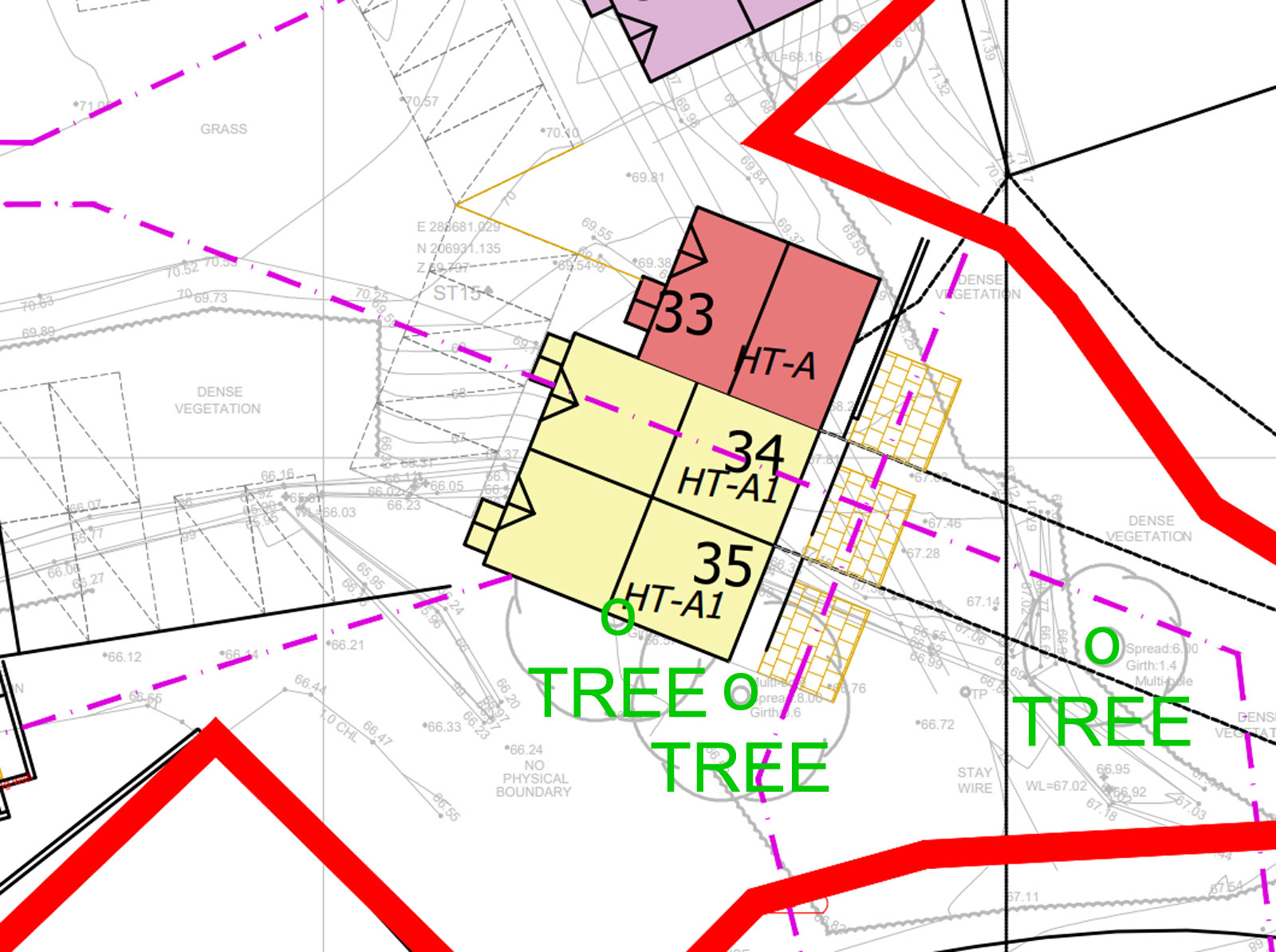
TREE SURVEY Tree survey around the site, does not include the woods at Woodland Park 
REVISED LEVELS A plan of the whole site which shows revised levels.
TREE CONSTRAINTS I'm not sure the purpose of the document, I've initially assumed it is showing the trees to be retained, however the plans show them building on at least one tree, see image below

47.jpg (317422 bytes)

DRAINAGE STORAGE SYSTEM Document showing drainage storage tanks integrated with the culverted stream.

46.jpg (516307 bytes)


HOW TO OBJECT

Due to the corona virus pandemic, the only way to object at present is by sending an email direct to planning@npt.gov.uk

You will need to include the following information

The date:

Your name and address

Application No.- P2020/0195 

Site address - Land South Of Heol Y Glyn Glynneath Neath.

The reason/s why you are objecting to the application.


SOME REASONS YOU CAN USE - PLEASE FEEL FREE TO COPY AND PASTE THESE NOTES INTO YOUR OBJECTION

I would like to object to the planning application P2020/0195 for the following reasons:


HISTORICAL CONTAMINATION

Several residents in the area have witnessed what they would consider to be illegal dumping by the Cuddy Group including barrels of possible toxic waste and asbestos. It should be noted that asbestos removal and remediation was at the core of the Cuddy Group's business. One resident who worked previously as a sub-contactor with the Cuddy Group witnessed several instances of illegal tipping by the company while he was working with the Cuddy Group.

There is also a significantly high probability that the land is contaminated from its use as an ash tip circa 1940-1960. The Environment Agency states that 100% of such municipal tips are contaminated. Ash from house coal has high carcinogenic properties.

In 2008 a Geo-Technical report which tested the land and confirmed that it was contaminated was submitted to the NPTC. Even though the land was inadequately tested to a depth of less than 2 metres it was found that two thirds of the soil samples tested were found to be contaminated. This would suggest that nearly 70% of the Enzo site is contaminated. Two of the contaminants found in 2008 are classified as grade 1 carcinogens. 

The Geo-Technical report provided evidence of a pathway from source to receptor and included a remediation strategy and a validation report. This is clear evidence the surveyors considered the level of contamination to be either Category 1 or Category 2 human health contamination. If land contains either of these categories then the council has a responsibility to ensure that the land is remediated under the UK Governments Environmental Protection Act 1990.

There is no evidence of any liaison between the planning department and the Contaminated Land Team at the Neath Port Talbot Council in 2008. In 2009 the Cuddy Group withdrew the planning application with the report containing the contamination and it was never seen again in the planning process.

In 2010 the Cuddy Group submitted a new planning application and a Geo-Technical report without any chemical testing. The Cuddy Group re-defined the land as a 'brownfield' site which would suggest that remediation had already taken place. There is no evidence of this. The Cuddy Group have bypassed the remediation of the contaminated land process. 

We would like to see a thorough investigation of the land for actual and potential contamination of the site down to its natural ground level. 


POSSIBLE CONSEQUENCES OF CULVERTING THE STREAM

FLOODING - Culverting the stream will increase the run of off surface water from the site to lower parts of Brynhyfryd and Woodland Park. The stream runs the complete length of Brynhyfryd and captures 100% surface water run off from the current land area of the site. If the stream is culverted then any water bypassing the on-site drainage will increase the flooding that is currently taking place in the lower parts of Brynhyfryd and Woodland Park during periods of heavy rain, storm periods and torrential downpours. It is impossible for the on-site drainage system to capture all rainfall and removing the stream will increase significantly flooding to the lower parts of Brynhyfryd and Woodland Park. The stream runs on a fault line in the earths crust and this is the most likely place for subsidence and/or an earthquake. Should the stream tunnel become blocked then the water entering at the cemetery end of Brynhyfryd will have nowhere to go. Once the stream is blocked, the lower part of Brynhyfryd will become a basin holding approximately 2 metres of water, houses and gardens will fill with water until it overflows into Old Pont-Neath-Vaughan Road. There will then be a continuous flow through the houses in Brynhyfryd, Old Pont-Neath-Vaughan Rd, Aberdare Road and Ynys Las until the tunnel is unblocked. This may take days or weeks. The same situation will happen if a large branch gets trapped on a bend in the tunnel or at the entrance.  Tunneling the stream removes the water's natural flow to the River Neath and will risk the properties and lives of those living in lower Brynhyfryd.

PRIVACY - Culverting the stream will bring the development houses back to back with the Brynhyfryd houses and there will be a loss of privacy to the property with in many cases the new houses overlooking the residents of Brynhyfryd.

CONTAMINATION - Culverting the stream will increase the danger of the carcinogens in the contaminated land and other toxic waste illegally dumped on the land affecting the health of residents. This resident would like to see a professional resident led testing of the tipped material on the site.

CONSERVATION - Culverting the stream will have a major conservation impact and promote climate change. The following recommendations appear in the "Ecological Appraisal Report:" highlighting the fact that the stream is a Site of Importance for Nature Conservation thereby providing evidence that culverting the stream would have a Major negative impact on the natural wildlife of the area. The following paragraphs appear in the report:

If we refer to section 4.4.3 of the Ecological Appraisal we will see that the stream is considered to potentially provide habitat for Water Vole and Otter; additionally, it will provide habitat for Amphibians and a range of invertebrates. The stream’s value is considered to be High Local as it is designated as a Watercourse Site of Importance for Nature Conservation by NPTC and its loss without mitigation would be Major. (Major is the highest level of impact criteria - Loss of feature and/or quality and integrity of feature; severe damage to key characteristics, features or elements.)

5.2.2 Scrub and trees should be retained wherever possible, particularly where they offer connectivity to adjacent habitats.

5.3.1 The stream is a SINC (Site of Importance for Nature Conservation) and considered to provide habitat for a range of species. 

The opinion of the consultant who undertook the initial survey of the site is that the stream is retained in its current state (i.e. open, and not culverted), and protected from effects of development during construction and operational phase. A drainage plan will inform appropriate protection of the stream and any ditches/associated features beyond the site. A minimum 7m vegetated buffer is required to protect the watercourse for Otter and Water Vole.

5.7.1 The stream should be retained and protected from development (as 5.3.1 above). A method statement and mitigation plan should be prepared in order to protect amphibians during site clearance and construction.

5.10.2 Planning authorities must seek to maintain and enhance biodiversity in the exercise of their functions. This means development should not cause any significant loss of habitats or populations of species, locally or nationally and must provide a net benefit for biodiversity.

In 2014 the NPTC introduced the Local Biodiversity Plan showing a commitment to protecting environments for the benefit of future generations. The council's priorities have changed since 1989 and are aimed towards a cleaner friendlier environment. In 2016 the Local Biodiversity Action Plan aligned itself with the Environment Wales Act (2016). Section 6 of this act places a duty on public authorities to ‘seek to maintain and enhance biodiversity’ and seek to ‘promote the resilience of ecosystems’.Section 7 lists both Priority Species and Habitats of Principle Importance for the purpose of maintaining and enhancing biodiversity in relation to Wales. The stream is considered a Habitat of Principle Importance.


Due to the corona virus pandemic, the only way to object at present is by sending an email direct to planning@npt.gov.uk

You will need to include the following information

The date:

Your name and address

Application No.- P2020/0195 

Site address - Land South Of Heol Y Glyn Glynneath Neath.

The reason/s why you are objecting to the application.

CLICK HERE FOR A LIST OF REASONS YOU CAN USE


LINKS - https://planningonline.npt.gov.uk/online-applications/applicationDetails.do?activeTab=externalDocuments&keyVal=Q6F34WKZI5U00

INFO/RESOURCES/

  If we refer to one of the Enzo Group's previous developments where Enzo Developments paid to have 70 protected tree chopped down including a rare 120 year old Redwood, we will see that conservation is not on the list of priorities for the Enzo Group - https://www.bbc.co.uk/news/uk-wales-50061303


Search the website with Google


HOME